
Heat mapping updates improve accuracy of RYA’s UK Coastal Atlas of Recreational Boating
Since 2004, the Royal Yachting Association (RYA) has been collecting information about recreational boating to gain a better picture of the areas most utilised for general boating, racing and passage-making, as well as the distribution of clubs, training centres and marinas, to create the UK Coastal Atlas of Recreational Boating.
The Atlas provides vital data on recreational boating activity around the UK, which the RYA can utilise on behalf of its members to help protect areas of importance to recreational boaters, and is taken into account by developers in designing new development proposals and in discussions over navigational safety.
“It is important that recreational boating activity is given due consideration by the Government when it balances competing interests in commercial, environmental and leisure sectors around the UK coast,” comments Phil Horton, RYA Environment and Sustainability Manager.
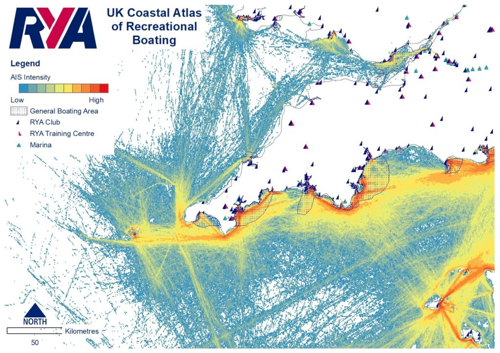
The latest edition of the Atlas, updated in September 2019, takes a new approach to mapping recreational boating use, updating its ‘heat map’ style based on Automatic Identification System (AIS) data, resulting in an increased range and resolution.
“This approach is based on tangible passages and accurately portrays the behaviour of recreational vessels regardless of differing weather conditions, providing a robust picture of UK cruising activity,” Phil adds.
In earlier versions, vessel activity was indicated by individual lines, but with the heat mapping approach, recreational activity is no longer represented as confined to distinct routes with no activity in the gaps between lines, almost full coverage is now provided. It also indicates light to heavy vessel activity and provides a very useful source of data for those considering recreational boating activity when mapping proposed offshore developments and areas for conservation.
“Developers are keen to licence the data, as it ensures they are aware of competing interests in a given location. Having this information from an early stage often means proposals can be developed which satisfy all parties. As more marine plans are being adopted, the Atlas helps developers safeguard areas used for recreational boating, and therefore conform to marine plan policies,” explains Phil.
Despite improving on previous data there are still some gaps.
“The updated AIS data provides increasingly good coverage of the UK’s coastal waters and beyond, however we are aware there are some data gaps, particularly in estuaries,” Phil continues. “As the data is limited to only those vessels carrying AIS transponders, it may exclude a large proportion of recreational craft.
“In these areas, where there is no AIS data coverage, we recognise this does not mean no recreational craft visit the area. For this reason, we also provide further data supplied by RYA clubs and other sources, utilising, in particular, the 2015 RYA club survey data.”
The RYA’s Coastal Atlas is used by government, local authorities, marine licensing authorities and renewable energy developers. It has also been shared with the general lighthouse authorities and the Maritime and Coastguard Agency (MCA) to help improve the safety of recreational boaters at sea and is used to inform marine planning processes.
“The Coastal Atlas data has proved vital when representing recreational boating interests, ensuring we have a seat at the table when discussions about navigational safety are underway and that boating interests are taken into account when new developments are proposed along the coast and offshore,” concludes Phil.
The RYA UK Coastal Atlas of Recreational Boating is available under licence as a digital download from the RYA’s environment team. Email environment@rya.org.uk for more information.